
Nepal is unquestionably a naturally beautiful nation with lovely weather all year. Seasons in Nepal are split into five weather zones due to its geographical diversity: tropical, tropical zone, temperate zone, cold zone, sub artic zone, and arctic zone. Nepal’s climatic conditions differ from one location to the next due to topographical factors. Summers in the north are cold, and winters are severe, whilst summers in the south are tropical, and winters are moderate. Spring, summer, monsoon, autumn, and winter are the five major seasons in Nepal. For every 1,000 meters gained in altitude, the average temperature drops by 6°C. Summer temperatures in the Terai reach 37° C and more in some regions, while winter temperatures range from 7°C to 23°C. Summers in mountainous regions are mild, with cool hills and valleys, but winter temperatures can drop below zero. The climate of the Kathmandu valley is pleasant, with average summer and winter temperatures of 19°C–35°C and 2°C–12°C, respectively.
Autumn (September, October-November) and spring Nepal (March, April and May) are the best seasons for trekking in. Short treks and certain Tea House treks are also possible in the winter and summer. While trekking, you must be prepared for rapid weather changes. As a result, hiking equipment should be carefully selected prior to the journey. Sudden rainstorms or snowfall are always a risk that must be taken into account. During the trekking season, the weather is a little more predictable.
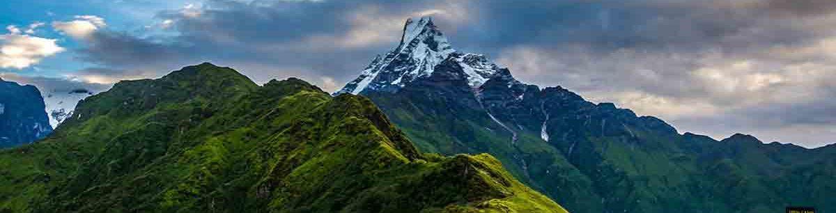
The four seasons of Nepal are depicted below:
Spring (March-May):
Nepal’s spring season, also known as the Pre-Monsoon season, begins in March and lasts till May. In various sections of the country, you can witness a wide variety of flowers blossoming during this season, including the national flower Rhododendron, magnolia, and other wildflowers. The months of March and April are regarded the second-best trekking months in Nepal. Because high passes are normally snow-free at that time of year, and the mountain views are still clear in April. Spring in Nepal is known for its changeable weather, with mild days and nights and temperatures that are neither too hot nor too cold.
Summer (June-August):
Summer is also Nepal’s monsoon season. In Nepal, the summer season begins in June and lasts through August. During the summer, it almost always rains, with the exception of a few thunderstorms. In some parts of Nepal, excessive rainfall during the summer can also create landslides. The temperature ranges from 20 to 35 degrees. The Terai and hilly regions, on the other hand, receive substantially greater temperatures due to the searing sun. The month of June has brought sunny and scorching days to the country. In the mountains, the weather is the most pleasant. The temperature in the center sections is around 84°F during the day and 64°F after dusk. The summer monsoon adds a lot of precipitation to the area. Precipitation levels in the north are around 375 mm, 340 mm in the center, and 45 mm to 130 mm in the south.
Autumn (September-November):
Autumn, also known as Post Monsson season in Nepal, occurs in September, October, and November. The weather in Nepal is still summer-like until the end of September. The temperature cools down in October, and the amount of precipitation decreases. In November, temperatures in various parts of the country average around 84°F during the day and 60°F at night. The temperature in the center of the country is around 70°F during the day and 44°F at night. Nepal receives a huge number of tourists throughout the autumn season. Autumn is the greatest time to visit Nepal because the weather and temperature are pleasant. Autumn is characterized by clear skies and a cool climate. Furthermore, Dashain and Tihar, Nepal’s two largest festivals, are celebrated throughout the autumn.
Winter (December-February):
The winter season in Nepal lasts from December to February. The winter days are cool and sunny. Winters are bitterly cold, with snowfall on occasion at higher elevations. The temperature in the South reaches 77°F during the day and 51°F at night. The temperature in the capital and other central cities of the country is around 66°F in the afternoons and 41°F at night. The daytime temperature in the northern parts of the country ranges from 41°F to 17°F, with a low of 26°F at night. The temperature at night is around 0°F. The air temperature in the Central regions ranges from 10°F to 36°F at this time of year. It is significantly warmer in the southern regions, with an afternoon temperature of around 73°F. The coldest region is the North-East, where the air temperature is 10°F in the daytime. In January, there are 1-2 rainy days with a total precipitation of 20-25 mm. If you want to experience snowfall, now is the best time to visit Nepal. Even in Kathmandu’s closest hill stations, such as Kalinchowk, you can enjoy snow.
Nepali Seasons:
Basanta Ritu (mid-March to mid-May):
In Nepali, the spring season is known as Basanta Ritu. It lasts two months, from the middle of March until the middle of May. It corresponds to Chaitra and Baisakh in the Nepali calendar. Basanta Ritu occurs after Shishir Ritu, during Nepal’s winter season. This season, trees have sprouted new buds and flowers have bloomed. It’s also a comfortable temperature, not too cold or too hot. During Basanta Ritu in Nepal, you can expect windy days and nights.
Grishma Ritu (mid-May to mid-July):
Grishma Ritu occurs in the English calendar from mid-May to mid-July. It is the month of Jestha and Aashad according to the Nepali calendar. Grishma Ritu (Nepal’s summer season) is the hottest of all the country’s seasons. Flowers fade and fruits ripen on trees. This is the greatest time to plant a crop in agriculture. During this season, farmers cultivate summer crops such as rice.
Barsha Ritu (mid-July to mid-September):
It lasts from mid-July to mid-September, according to the English English calendar. Similarly, according to the Nepali calendar, Barsha Ritu begins in the month of Shrawan and finishes in the month of Bhadra. In Nepal, the rainy season is known as Barsha Ritu. In English, Barsha means rain. Raindrops from the sky are virtually always present during this season. For farmers, this season is notable for paddy planting.
Sharad Ritu (mid-September to mid-November):
Nepal’s Autumn season, Sharad Ritu, begins in Ashwin and concludes in Kartik on the Nepali calendar. Sharad Ritu is observed from mid-September to mid-November on the English calendar. Sharad Ritu is the festival season. The key attractions of the season are Nepal’s major best festivals, Teej, Dashain, and Tihar. Because of the good weather, peaceful environment, neither hot nor cold, and amazing mountain vistas, Sharad Ritu is also known as the finest time to visit Nepal for adventure sports like as trekking and peak climbing.
Hemanta Ritu (mid-November to mid-January):
Ritu Hemanta, The Nepali calendar’s pre-winter season begins in the month of Mangsir and concludes in the month of Poush. It falls between mid-November and mid-January on the English calendar. The weather begins to drop, and people begin to prepare for the coming winter. Farmers are hard at work in the fields of agriculture.
Shishir Ritu (mid-January to mid-April):
Shishir Ritu, Nepal’s winter season, begins in the month of Magh and finishes in the month of Falgun on the Nepali calendar. It occurs between the middle of January and the middle of April on the English calendar. This Shishir Ritu season is the coldest of Nepal’s entire seasonal year. During this season, snow falls on a daily basis in a high-altitude locale.


