
Not everyone finds the winters to be boring. For certain folks, winters are undoubtedly heavenly, to put it mildly. We enjoy hot chocolate, cozy blankets, and bonfire parties to counteract the chilly breeze and bitter cold of winter.
The season of chilliness is typically characterized by gloomy sky and runny noses. But the season also has a charming side that is generally overlooked. The best time to begin making preparations for a winter snow holiday is as the temperature cools.
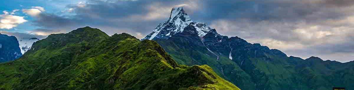
The snow also favors us during this time of year with its breathtaking beauty, turning any area that experiences snowfall into a white snowy spread of complete delight. Snowfall is unquestionably breathtaking.
A snowman must be built, snowballs must be thrown, and the tingling, numbing sensation of newly fallen snow must be felt. The hills around the Kathmandu valley reach heights of over 2500 meters and range in altitude from 1200 to 1600 meters above sea level.
With the rare chance to take in the stunning snowfall in the Kathmandu valley’s outskirts and hill stations, the winter wonderland comes to life.
The amazing Himalayan views, a wide variety of vegetation, and wildlife, as well as the wonderful snowfall experience in winter, are among the hilltops’ most impressive main draws.
If you’re in Kathmandu during the winter, consider visiting one of these snowy places nearby.
Phulchowki:
The highest point hill encircling the Kathmandu valley is Phulchoki, which is situated 20 kilometers to the southeast of Kathmandu at a height of 2762 meters above sea level.
With the Himalayas in the background to the north and the Terai plains in the south, it provides a stunning perspective of the Kathmandu valley. Phulchowki is a well-known hotspot for viewpoints because of the Himalayas in the background to the north and the magnificent view of the entire Kathmandu valley.
It is starting to gain popularity as the majority of bikers’ preferred option for a day trip away from the chaos of Kathmandu. Along with the snowfall, the hill is famous for bird watching, biking, and hiking.
Shivapuri:
Another excellent place to see snow during the winter months close to Kathmandu is Shivapuri Hill Station. In addition to offering panoramic views of mountains like Mt. Manaslu, Ganesh Himal, Gaurishankar, and Langtang, Shivapuri, just north of Kathmandu, is renowned for its orchids, rhododendrons, and other types of flora that grow on the center hill. The city’s most popular hiking destination is Shivapuri Hill, the second-tallest hill in the Kathmandu Valley.
The hill is much more lovely in the winter with clear views of the mountains and snowflakes if you compare it to the spring when it is covered in flowering rhododendrons.
The Bagmati River’s source, Bhagdwar, is close by, and this area of the hill has the highest probability of snowfall of any place from the base to the top. Before you leave, be sure the weather is cold enough for snow because snowfall can occur at any time during the winter.
Chandragiri:
Given its proximity and the availability of a cable car, Chandragiri is one of the valley’s most popular tourist destinations. People travel there to enjoy the snowfall and to visit.
It is situated at a height of 2551 meters above sea level. As the site of the historic Bhaleshowr Mahadev Temple, Chandragiri Hill is a well-known hilltop in the Kathmandu valley.
You can visit it in the winter and for religious and pilgrimage purposes. Chandragiri is undoubtedly a stunning, abundant, and untouched terrain, with towering peaks like Annapurna, Everest, Manaslu, and Ganesh, as well as amazing views of the entire Kathmandu Valley covered in a dense layer of vegetation.
Daman:
Daman is located 75 kilometers southwest of Kathmandu Valley. It has an elevation of 2322 meters above sea level and receives a lot of snowfall each year.
This is the main reason that every year, more than 5,000 people come here to experience the wintertime snowfall.
The Himalayas, hills, fresh waterfalls, and lush forests can all be seen from here in a stunningly spectacular manner. Daman can be reached in two ways. Either take a bus from Kalanki to Daman, or hike through Chitlang.
Lakuribhanjyang:
Lalitpur, Bhaktapur, and Kavre all have influence over Lakuri Bhanjayang. You must take a bus from Lagankhel to Lubhu-Panauti in order to get to Lankuri Bhanjayang.
Lakuri Bhanjayang is 19 kilometers away and accessible only by its own means. Lagankhel and Lubhu are both 7 km and 12 km apart from Lankuri Bhanjayang, respectively.
It is well known for picnics and snow sports and is close to the valley. Ten kilometers of descent from Lakuri Bhanjayang will get you to Panauti.
Kalinchowk:
The elevation of Kalinchowk is 3,700 m. After a trip from the Kathmandu Valley to Kuri, Charikot, and a 1-2-hour trek, we arrive at this location. Both natural and cultural treasures are abundant in this area.
This location receives snowfall during the winter, making it a favorite camping and snow-playing destination during the previous few years. Views of numerous Himalayan peaks, including Ganesh Himal, Shisha Pangma, Langtang, Dorje Lakpa, Jugal Himal, Gauri Shankar, and others, are available to tourists.
It became a well-liked resort because of the mountains’ incredible topographical differences, natural beauty, and rich cultural value. Additionally, the Kalinchowk temple is a wonderful refuge from winter near the Kathmandu valley since it combines beauty and religious needs.
Nagarkot:
Nagarkot lies 32 kilometers east of the Kathmandu Valley at a height of 2175 meters above sea level. Friends and family come here frequently to see the sunrise and sunset.
You can go play snowfall when it rains a lot in the autumn and winter. Additionally, you may take in the spellbinding vistas of numerous mountains, including Gauri Shankar, Langtang, Mount Everest, and others.


