
Trekking in Nepal is one of the most enriching travel experiences in the world, and among its many legendary routes, the Manaslu Circuit Trek stands out for its pristine landscapes, cultural authenticity, and off-the-beaten-path allure. Named after Mount Manaslu, the eighth-highest mountain in the world at 8,163 meters, this trek offers a perfect balance of breathtaking scenery, remote village life, and Himalayan adventure.
If you’re considering the Manaslu Trek, this comprehensive guide covers all the essential things you need to know—from permits and best seasons to trekking highlights, difficulty, logistics, and what makes it one of Nepal’s best-kept secrets.
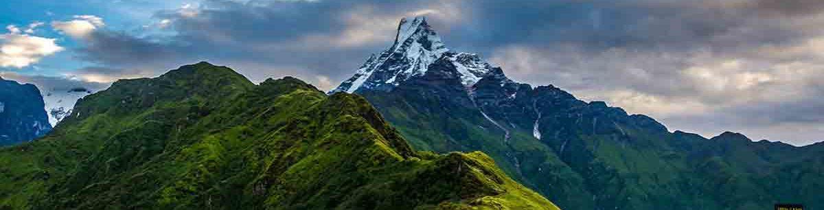
Why Choose the Manaslu Trek?
While the Everest and Annapurna regions attract tens of thousands of trekkers annually, the Manaslu Circuit offers a more peaceful and unspoiled alternative. Opened to trekkers only in the early 1990s, it still retains a sense of isolation and authenticity that’s hard to find elsewhere in the Himalayas.
What Makes It Special?
- Less crowded than Annapurna and Everest regions
- Remote villages and rich Tibetan-influenced culture
- Epic mountain scenery, glaciers, and river valleys
- Larke La Pass (5,106 m) – one of the most beautiful Himalayan passes
- Opportunities to observe diverse ecosystems and wildlife
- Traverses the Manaslu Conservation Area, rich in biodiversity
Trek Overview
| Feature | Details |
| Duration | 14–18 days (typical itinerary) |
| Highest Point | Larke La Pass – 5,106 meters (16,752 ft) |
| Trek Distance | Approx. 177 km (110 miles) |
| Starting Point | Soti Khola (or Arughat) |
| Ending Point | Dharapani (connects with Annapurna trail) |
| Difficulty Level | Moderate to challenging |
| Best Time to Trek | March–May & September–November |
| Accommodation Type | Teahouses (basic lodges) |
| Permits Required | Yes – Restricted Area Permit + others |
Permits You Need
The Manaslu region is classified as a Restricted Area by the Government of Nepal, meaning that independent trekking is not allowed. You must be part of a registered group and accompanied by a licensed guide.
Required Permits:
- Manaslu Restricted Area Permit (RAP)
- Cost: $100 for the first 7 days (Sept–Nov), $15 per day after
- Lower rates from Dec–Aug
- Manaslu Conservation Area Permit (MCAP) – NPR 3,000 (~$25)
- Annapurna Conservation Area Permit (ACAP) – NPR 3,000 (~$25)
- TIMS Card is not required if you have a RAP
Permits can be obtained through a registered trekking agency, and solo trekking is not permitted in the Manaslu region due to safety concerns.
Best Time to Trek the Manaslu Circuit
The ideal seasons for the Manaslu trek are:
1. Autumn (September–November)
- Most popular and stable trekking season
- Clear skies, mild temperatures, and great mountain visibility
- Festive season in Nepal—Dashain and Tihar fall during this time
2. Spring (March–May)
- Blooming rhododendrons and wildflowers
- Longer days and warmer weather
- Good mountain visibility, though occasional haze
Avoid:
- Monsoon (June–August) – Heavy rain, landslides, and leeches
- Winter (December–February) – Snowfall can close Larke Pass
Trekking Itinerary (Standard 14-16 Days)
Here’s a popular 14-day itinerary. It can be extended or shortened depending on your pace and acclimatization needs.
Day 1: Drive from Kathmandu to Soti Khola (700m)
- 7–8 hour jeep or bus ride
- Overnight stay in a teahouse
Day 2–4: Trek through Machha Khola → Jagat → Deng
- River crossings, waterfalls, and terrace farming
- Enter the restricted area at Jagat
- Deng offers views of Shringi Himal
Day 5–6: Deng to Namrung → Lho
- Climb through pine and rhododendron forests
- First panoramic views of Mount Manaslu from Lho
- Lho is a beautiful Tibetan village with a large monastery
Day 7–8: Lho to Samagaun (3,530m)
- Rest and acclimatization day at Samagaun
- Side trip: Manaslu Base Camp or Pungyen Gompa
Day 9: Samagaun to Samdo (3,860m)
- Short, gradual climb
- Samdo is the last permanent settlement before the pass
- Close to the Tibetan border
Day 10: Acclimatization in Samdo or hike to Dharamsala (Larke Phedi)
Day 11: Cross Larke La Pass (5,106m) to Bimthang (3,590m)
- Long, challenging day with early morning start
- Stunning panoramic views from the pass
- Descend to Bimthang for overnight rest
Day 12–13: Trek to Dharapani via Tilje → Drive to Besi Sahar or Kathmandu
- Reconnects with the Annapurna Circuit trail
- Jeep or bus from Dharapani or Besi Sahar back to Kathmandu
Top Sights and Highlights
Mount Manaslu (8,163 m)
Visible from various points, this majestic peak dominates the landscape and inspires awe.
Ribung and Pungyen Gompa
Ancient Buddhist monasteries offering cultural insight and panoramic views of the Manaslu range.
Larke La Pass (5,106 m)
The high point of the trek and a physically demanding but incredibly rewarding climb with sweeping views of Himlung Himal, Cheo Himal, and more.
Remote Tibetan Villages (Samagaun, Lho, Samdo)
Experience local hospitality, Tibetan-style architecture, prayer wheels, and mani walls.
Wildlife and Biodiversity
- Snow leopards (rarely seen)
- Himalayan tahr, blue sheep, marmots, eagles
- Varied flora—pine, birch, rhododendron, medicinal herbs
Food and Accommodation on the Trek
Accommodation:
- Teahouses are available in most villages
- Basic rooms with shared bathrooms
- Heating usually available only in the dining hall
Food:
- Dal Bhat (lentils & rice) – staple meal
- Momos, noodles, pasta, Tibetan bread, fried rice
- Expect rising prices and reduced menus at higher elevations
- Bring snacks, protein bars, or instant coffee for variety
What to Pack
Essentials:
- Sturdy hiking boots
- Thermal layers, waterproof jacket
- Sleeping bag (0°C to -10°C comfort rating)
- Trekking poles
- Headlamp, water purifier/tablets
- Sunscreen, sunglasses, lip balm
- Personal medications and basic first-aid
- Extra cash (no ATMs on the trail)
Pack light but smart—porters (if hired) typically carry up to 15 kg.
Guide and Porter Info
- Licensed guide is mandatory for the restricted area
- Hiring a porter is optional but helpful
- Many agencies offer guide + porter packages
- Ensure your guide is experienced and fluent in English
Hiring locals not only enhances your safety but also contributes to the local economy.
Responsible Trekking Tips
- Respect local customs—ask before taking photos of people or religious sites
- Avoid plastic bottles—bring a reusable water bottle with purification options
- Leave no trace—carry your waste out of the conservation area
- Support local teahouses and businesses
- Be mindful of altitude—acclimatize properly and don’t rush the itinerary
Alternative Routes & Extensions
- Tsum Valley Extension: Add 5–7 days to explore this secluded valley with sacred monasteries and Tibetan heritage
- Combine with Annapurna Circuit: After reaching Dharapani, continue the Annapurna trail westward
Final Thoughts: Is the Manaslu Trek Right for You?
If you’re looking for a Himalayan trek that offers solitude, cultural immersion, and dramatic mountain scenery without the crowds, the Manaslu Circuit is an outstanding choice. It demands good fitness, some experience with altitude, and a sense of adventure—but the rewards are truly unforgettable.
From ancient Buddhist villages to panoramic glacier views, and from deep gorges to high passes, the Manaslu region is a raw and authentic slice of Nepal. Plan well, trek responsibly, and you’ll come away with memories that last a lifetime.


